Hiking Mount Sabinyo in Mgahinga: An Adventure Guide
The Mountain Where Borders Converge
There are mountains that captivate the imagination with their sheer height, and then there are mountains that draw adventurers with their character, their stories, and their unique positioning in the world. Mount Sabinyo, rising majestically within the Mgahinga Gorilla National Park, is one such marvel. Known locally as “the old man’s teeth” because of its rugged, jagged peaks, Mount Sabinyo offers not only a physical challenge but also a spiritual and cultural journey through one of Africa’s most pristine landscapes.
Unlike other volcanoes in the Virunga range, Mount Sabinyo carries an extraordinary geographical distinction: its summit marks the point where the borders of Uganda, Rwanda, and the Democratic Republic of Congo converge. To stand atop this mountain is to step simultaneously into three countries, a feat that elevates the experience of climbing Sabinyo from a mere hike to a symbolic crossing of boundaries.
In this adventure guide, the allure of Mount Sabinyo will be explored in depth. From its location and ecological wonders to the challenges of its climb, the cultural resonance it holds, and the best times to embark on the journey, every detail unfolds to prepare the traveler for an expedition that is as rewarding as it is demanding.
Location of Mount Sabinyo
Mount Sabinyo lies within Mgahinga Gorilla National Park, which occupies the southwestern corner of Uganda. This park forms part of the wider Virunga Conservation Area, a transboundary ecological treasure shared with Rwanda and the Democratic Republic of Congo. The volcano itself rises to an elevation of 3,669 meters, making it one of the prominent peaks in the Virunga chain.
Although not the tallest in the range, Sabinyo stands out because of its deeply eroded ridges, which give it a rugged and ancient look compared to its younger volcanic neighbors. Its flanks are cloaked in bamboo and montane forests that shelter unique wildlife, including the endangered mountain gorillas, golden monkeys, and countless bird species endemic to the Albertine Rift.
Access to the mountain is through Uganda, with the trailhead located at the Ntebeko Visitor Center in Mgahinga Gorilla National Park. The journey to this point is an adventure in itself, often involving a scenic drive through the terraced hills of Kabale and Kisoro, where volcanic backdrops and mist-laden valleys create a fitting prelude to the hike.
The Unique Character of Mount Sabinyo
What makes Mount Sabinyo so distinct is not just its geographical positioning but also its dramatic topography. Unlike smoother volcanic cones such as Mount Muhabura, Sabinyo is heavily eroded, leaving behind jagged peaks and ridges that resemble worn-out teeth. These formations are what inspired the name “Sabinyo,” a local term that translates to “old man’s teeth.”
The mountain’s rugged slopes present a variety of ecosystems. The lower altitudes are dominated by dense bamboo stands, home to golden monkeys that dart between stems in playful agility. Ascending further, the vegetation transitions into montane forests teeming with birdlife, before giving way to subalpine heathers draped in lichens. Each of these zones tells a story of adaptation, survival, and beauty, making the climb not only a physical pursuit but also an ecological expedition.
At the summit, three pointed ridges extend outward, marking the borders of Uganda, Rwanda, and the Democratic Republic of Congo. Few places on Earth offer such a tangible sense of standing at the crossroads of nations, where cultures and landscapes blend seamlessly under the same sky.
The Hiking Experience
Hiking Mount Sabinyo is not for the faint-hearted, yet it rewards those who embrace its challenges with unforgettable experiences. The trail begins at Ntebeko Visitor Center, where hikers are briefed by park rangers about the route, safety measures, and the natural wonders they will encounter.
The ascent typically takes between seven to eight hours to complete as a round trip, depending on pace and weather conditions. The first sections of the trail wind gently through bamboo forests, where rustling leaves and the occasional glimpse of golden monkeys create a lively atmosphere. As the altitude increases, the terrain becomes steeper, requiring endurance and determination.
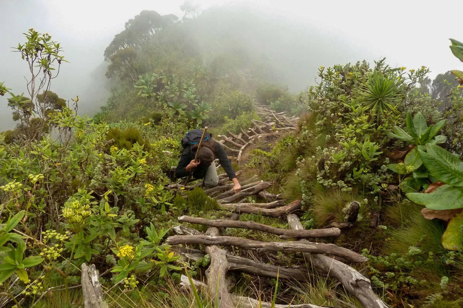
Sabinyo is renowned for its wooden ladders and steep ridges, which must be navigated carefully under the guidance of experienced rangers. These ladders are placed in areas where erosion and natural wear have created vertical challenges that cannot be overcome on foot alone. For many hikers, negotiating these ladders is both thrilling and daunting, adding an adrenaline-fueled edge to the adventure.
As the climb continues, the forest canopy opens to reveal sweeping vistas of the Virunga range. On clear days, views extend to the glacial peaks of the Rwenzori Mountains, the shimmering expanse of Lake Bunyonyi, and even the sprawling landscapes of Rwanda and Congo. The final push to the summit is steep and demanding, but the reward is incomparable—standing at the tri-border point, where three nations meet in harmony on the tip of an ancient volcano.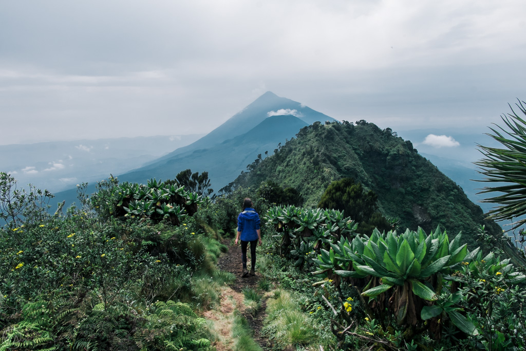
Ecological Richness of Sabinyo
The slopes of Mount Sabinyo are a living museum of biodiversity. The bamboo forests that dominate the lower altitudes are vital ecosystems, sustaining not only golden monkeys but also mountain gorillas, elephants, and a range of smaller mammals. The bamboo shoots form a crucial food source for many of these species, highlighting the delicate balance of life in this habitat.
Further up, the montane forests are alive with the songs of birds. Sabinyo is part of the Albertine Rift, one of Africa’s most important birding regions, and hosts species such as the Rwenzori turaco, the handsome francolin, and the regal sunbird. Above the treeline, the subalpine zone features hardy plants like giant lobelias and senecios, whose adaptations to cold and wind showcase the resilience of nature.
For the hiker, each step on Sabinyo’s trail is an immersion into a layered ecological tapestry. It is not just a climb to the top of a volcano but a passage through habitats that illustrate the evolutionary wonders of the East African highlands.
Cultural Significance
Mount Sabinyo is more than a natural landmark; it is also steeped in cultural and spiritual significance. For local communities, the Virunga volcanoes are not mere geological formations but sacred spaces tied to myths, traditions, and ancestral reverence. Sabinyo, with its distinctive peaks, is often regarded as a mountain of wisdom and authority, a place where the spirits of ancestors are believed to reside.
The Batwa people, indigenous forest dwellers of the Virunga region, hold unique cultural connections to the mountain and the surrounding forests. Their traditions, dances, and oral histories reflect an intimate bond with the land, offering visitors deeper insights into how human lives have long intertwined with these ecosystems. Engaging with Batwa cultural trails before or after the hike provides a holistic appreciation of Sabinyo as both a natural and cultural monument.
Challenges of Hiking Mount Sabinyo
The adventure of climbing Sabinyo lies as much in its challenges as in its beauty. The steep ridges and eroded gullies demand both physical stamina and mental resilience. The wooden ladders, though secure, require careful navigation and a steady nerve. For hikers unaccustomed to altitude, the thinner air near the summit can also add to the difficulty.
Weather is another unpredictable factor. The high-altitude climate of Mgahinga means that rain can fall unexpectedly, transforming trails into slippery tracks. Cold winds and mist often sweep across the slopes, reducing visibility and adding to the sense of unpredictability. Preparation with proper gear—such as sturdy hiking boots, warm clothing, and rain protection—is essential to ensure safety and comfort.
Despite these obstacles, the challenges of Sabinyo are precisely what make its summit so rewarding. Each hurdle crossed strengthens the sense of accomplishment, turning the climb into a transformative personal journey.
Best Time to Hike
Mount Sabinyo can be hiked throughout the year, but the dry seasons are generally considered the most favorable. From June to August and December to February, the trails are less muddy, and visibility is often clearer, allowing panoramic views from the summit. These months also coincide with peak tourism seasons, creating vibrant encounters with fellow adventurers.
The rainy seasons, stretching from March to May and September to November, present different charms. The vegetation flourishes with fresh vibrancy, and the fewer crowds offer a quieter, more solitary hiking experience. However, the trails can be more treacherous during these months, and extra caution is required.
Regardless of season, hikers must prepare for rapidly shifting mountain weather. A sunny morning can quickly give way to mist and rain, reminding visitors that Sabinyo’s moods are as dynamic as its landscapes.
Conservation and Tourism Balance
Hiking on Mount Sabinyo is not only a pursuit of adventure but also a vital contribution to conservation efforts. The fees paid for permits and guided hikes go directly into sustaining Mgahinga Gorilla National Park, funding anti-poaching patrols, habitat protection, and community development programs.
Tourism has also created economic opportunities for local communities, encouraging them to engage in conservation as a livelihood rather than as an obstacle. The presence of responsible hikers ensures that the unique ecosystems of Sabinyo continue to thrive while providing lasting benefits for the people who call the Virunga region home.
How to Get There
Reaching Sabinyo begins with a journey to Mgahinga Gorilla National Park in Kisoro District. By road, the trip from Kampala to Kisoro takes between eight to nine hours, winding through picturesque landscapes of rolling hills and fertile valleys. Alternatively, travelers may opt for scheduled or chartered flights from Entebbe or Kajjansi to Kisoro airstrip, followed by a short drive to the park’s Ntebeko gate.
The road journey itself is an immersion into Uganda’s scenic beauty, offering glimpses of Lake Bunyonyi and the terraced slopes that define southwestern Uganda. Once at the park, the Uganda Wildlife Authority organizes and oversees all hiking activities, ensuring safety and conservation standards are maintained.
The Deeper Meaning of the Climb
To hike Mount Sabinyo is to go beyond the physical act of reaching a summit. It is a journey into the very essence of East Africa’s natural and cultural identity. Every step through bamboo forests, every careful climb up a ladder, and every moment of silence in the misty heights contributes to a profound understanding of how landscapes shape both nature and human spirit.
At the summit, where three nations meet, the experience transcends borders. It becomes a meditation on unity, resilience, and the shared responsibility of conserving Earth’s wonders. For many, the climb up Sabinyo becomes a metaphor for life itself—a path marked by challenges, rewards, and the beauty found along the way.
Answering the Call of Sabinyo
Mount Sabinyo is not the tallest peak in Africa, nor the most famous, yet it offers one of the most rewarding adventures a traveler can undertake. Its rugged slopes, ecological treasures, cultural resonances, and symbolic summit converge to create an experience unlike any other.
For those who seek adventure beyond the ordinary, Sabinyo promises not just a hike but a journey of self-discovery, connection, and awe. It is an invitation to embrace nature’s grandeur, to honor cultural heritage, and to contribute to conservation in one of the world’s most extraordinary regions.
Travelers who wish to turn this dream into reality are encouraged to plan their African adventures with WildHorn Africa, a trusted name in creating unforgettable safaris and expeditions. With their expertise, dedication, and passion for showcasing the continent’s wonders, every journey to Sabinyo and beyond is guaranteed to be safe, seamless, and deeply rewarding.